Pages

I never follow directions or instructions..I love the sun on my face and I am a fan of all things..

Monday, July 31, 2017

Adirondack Mountains

We drove up in the Adirondack (which means porcupine in the Mohawk language) Mountains to Lake Placid, such magnificent beauty and scenic grandeur...
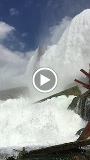
The Adirondacks are a group of mountains in north-eastern New York, the Adirondacks were created as a park in 1892 by the State of New York, this splendid park is now a constitutionally protected Forever Wild forest preserve and spans six million acres with over 3000 lakes, miles and miles of rivers and it includes over 2000 miles of hiking trails, these trails comprise the largest trail system in the nation. Many areas of the park are devoid of any types of settlements and there are no useable roads, it is a natural wilderness, unlike any other. The Mohawk and the Algonquin Indians used these Mountains for hunting and fishing..but they never settled here, it was probably too cold...
The Adirondacks covers one fifth of New York, it is the largest publicly protected park in the contiguous United States. Larger than several states in New England, bigger even than Yosemite, Yellowstone, Glacier, Grand Canyon and the Great Smokies National Parks combined. There are about one hundred peaks, ranging from 1200 to 5000 ft. the highest peak, is Mt. Marcy (it was called Tahawus or "cloud-splitter" by the Indians). 
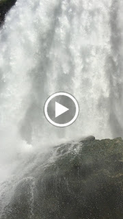
Esprit climbed us upwards to over 2000 ft, she was a champ about it, gave us no worries! Now my ears...on the other hand didn't think to highly about it! We stayed in a Park called the North Pole...so now I can say I have been to the North Pole! We drove around and saw some of the most wonderful forests, rivers and mountain peaks...towering above us.....the air was so crisp and clean, the rivers flowed over large boulders and so fresh!....it was great!


Saturday, July 29, 2017

Eric Canal and Fort Stanwix too

The Erie Canal is flowing with history, it is claimed to be one of America's most famous man-made water-ways. First proposed in the 1780s, its construction began in 1817 and it was primarily dug by hand...it opened in for traffic in 1825. The original Erie Canal had 83 locks, was 363 long and ran from Albany on the Hudson to Buffalo on Lake Erie, and it was cut 40 feet wide and 4 feet deep, with removed soil piled on the north downhill side to form a walkway known as a "towpath" for the mules and horses. In a time when bulk goods were limited to pack animals and there were no railways, water was the most cost effective way to ship bulk goods. The original canal was the first transportation system between the eastern seaboard, New York City and the western interior, The Great Lakes of the United States. 
Today the present Erie Canal rises 566 feet from the Hudson River to Lake Erie through 35 locks. From tide water level at Troy, the Erie Canal rises through a series of locks in the Mohawk Valley to an elevation of 420 feet above sea level at Rome. Continuing westward, it descends to an elevation of 363 feet above sea-level at the junction with the Oswego Canal, and finally rises to an elevation of 565.6 feet above sea-level at the Niagara River. We floated down the Erie Canal and went through lock 17.. at one time this was the highest lift lock in the world, raising and lowering vessels over 40ft...it was like going back in time..they still use equipment that is over 100yrs old and it still works perfectly. 


There is a fort in Rome, New York so after our Erie tours we took a tour of Fort Stanwix, this Fort was built to guard a portage between the main waterways southeastward to the Atlantic seacoast, down the Mohawk and Hudson rivers, then northwestward to Lake Ontario down Wood Creek and Oneida Lake to Oswego....Indians used this portage for centuries, they called it 
-Wain-Sta, or The Great Carrying Place.
Fort Stanwix has been almost completely reconstructed to its 1777 appearance, and they have people that wander around in period costumes. 


When they were excavating, prior to reconstructing the fort, a substantial quantity of 18th-century artifacts were unearthed and they offered some evidence of the activities that took place here during various periods of time during the fort's occupation.
Fort Stanwix was garrisoned until 1781, but played no further active part in the war. In October 1784, American and Iroquois representatives met here to negotiate the Treaty of Fort Stanwix, which set terms for a separate peace with the Indians and forced the Iroquois Confederacy to cede large parts of their lands to the United States. 
It was just another fort..but these Forts have such historic value and when I was walking around, I just can not help think about the people that used to inhabit these Forts and what they went through! It's mind blowing! 

Friday, July 21, 2017

Old Fort Niagara...and again to the Falls

Pierre and I went on a adventure to Old Fort Niagara, it sits on the banks of Lake Ontario and I wanted to put my feet in this Lake, that made all five Lakes that I have stood in!  So after I got my feet wet we decided to go see the Fort, now... I have said that if you have seen one Fort you have seen them all, but this was a wonderful Fort..I was impressed! This Forts history spans more than 300 years and the Forts commanding presence on the Great Lakes caused it to play a key role in the French War, Indian Wars, the American Revolution and the War of 1812. 
The importance of the Fort Niagara site was because of its location. The Great Lakes and their connecting straits form a continuous body of water from the Atlantic Ocean to the center of the North American continent, and along the southern and western edge of the lakes lies a continental divides which separate the tributary streams of the Great Lakes from draining into the Gulf of Mexico, now the Indians and the early Europeans, used these waters as a natural highways through rugged and heavily forested land. 
The fort was occupied by three nations: France, Great Britain, and the United States and the French established the first post in 1679 and built the cool French Castle in the middle in 1726. 

It still stands today...as you can see!
Then Britain gained control of the fort in 1759 during the French and Indian War and maintained control throughout the American Revolution, yielding it to the United States in 1796. Then the fort was captured by the British during the War of 1812 until being handed over again to the United States in 1815 after which time it served as a peaceful border post. 
Old Fort Niagara served as a training station and active barracks from the Civil War until the last army units were withdrawn in 1963. The Army was the last to leave and still today, it serves as a operating base for the United States Coast Guard making it one of the longest continuously run military bases in the Unites Stated, from 1726 to present day. 

\


They had a flag on display in the museum and this flag..like the Fort...has a wonderful story! Now the road back to Old Fort Niagara has been long and arduous for the flag the British captured on Dec. 19, 1813. After the Fort fell...an aide to Mac. Ten. Sir Gordon Drummond, the commander of the British forces in Upper Canada, arrived in Quebec to present the flag, as a trophy, to Sir George Prevost, British commander-in-chief of North America.
In May 1814, Prevost shipped the Niagara flag to London where it was laid before the feet of the Prince Regent, later King George IV.  Prince Regent returned the Fort Niagara flag to Gen. Drummond, whose family home was in Scotland. There it remained on display in a hallway for decades before word of its whereabouts reached Canada in 1984.
Unfortunately, it had been badly damaged by a fire in 1969. The flags owner the Lady Strange finally agreed to sell the flag (she needed a new roof on the castle) and it was taken to the Peebles Island Resource Center in Albany, a facility operated by the state Office of Parks, Recreation and Historic Preservation, to be restored. Then it was returned to Old Fort Niagara where the flag is now the centerpiece for the museum and visitors center at Old Fort Niagara!


After the Fort I wanted to go back to the Falls one more time. They impressed me so much. We went back over to Goat Island, then over to Luna Island to walk the boardwalk. This boardwalk takes you right beside Bridal Falls. When you stand on the boardwalk you can feel the power and the vibration right under your feet and hear the roar of the Falls...it is spectacular!


The channel of the Niagara River splits in two above the falls, creating two sets of falls, one on either side of the island, the Bridal Falls and the American Fall, but the Island stands firm and I saw a mama duck with her duckling swimming in the calm waters near the Island..it was quite the scene...
We also walked across the rainbow bridge so I could have one foot in the United States and one in Canada! 


We are setting out on a new adventure tomorrow, but.... I'll be back!

Wednesday, July 19, 2017

Niagara Falls

On the road to Niagara Falls, we decided to go through Canada and we made it into Canada, but the weather took a turn for the worst and it looked like we would be following the storm, so we turned around and headed back to Michigan. We stayed the night again in St Ignace at the same park we stayed at on the way up, then we headed out of Michigan. We stopped for the night in Frankenmuth Mi, they have one of the biggest Christmas stores I have ever seen and then we had lunch in Frankenmuth Brewery, it is one of the oldest breweries in Michigan. Pierre and I spent the rest of the day just checking out Frankenmuth.. I got to see and go across my first wooden covered bridge! 


We traveled right through Ohio and Pennsylvania,so we will have to go back, but I did get a picture of the
state signs as we went by. 
Then before I knew it we were in New York! That's right..New York! We are staying on Grand Island for a few days so we can see the American Niagara Falls and the Canadian Niagara Falls. I was so amazed that these gigantic falls are right downtown in Niagara Falls. We decided to take a guided tour that offered a ride on The Maid of the Mist, the Whirlpool, Goat Island, and the Cave of the Winds. Our tour guides name was Moe and he was chock full of information...having been born and raised in Niagara Falls! 
Now the features that became Niagara Falls were created by the Wisconsin Glaciation about 100,000 years ago, these same features also created the Great Lakes and the Niagara River. The water that passes over Niagara Falls comes from 4 out of 5 of the Great Lakes...Superior, Michigan, Huron and Erie. With a watershed reaching over 260,000 square miles, the Great Lakes are the largest fresh water basin in the world. About 2/3 of the fresh water on the continent flows over the Falls – that’s almost 1/5 of the fresh water on Earth! Imagine that!
There are three falls, the Horseshoe Falls, the American Falls and the Bridal Veil Falls. The Horseshoe Falls drop about 188 feet while the height of the American Falls varies between 70 and 100 feet because of the presence of the giant boulders at its base. The larger Horseshoe Falls are about 2,600 feet wide, while the American Falls are 1,060 feet wide and about 600,000 gallons of water flow over these falls every second! 90% of the flow of the Niagara River tumbles over the Horseshoe Falls, and only 10% flows over the American Falls. Here is a funny fact.. fish actually travel over the falls and about 90% of them survive! Experts believe that the white foam from the rushing waters cushions their fall! But a lot of them don't make it...making it a smorgasbord for the birds
We took a ride on the Maid of the Mist...all wrapped up in a blue poncho. The first Maid of the Mist was launched in 1846 to operate as a ferry across the river for carriages and stagecoaches. Today the Maid of the Mist takes you on a journey into the heart of North America’s most powerful waterfalls. You can hear and feel the thundering roar of  the water falling right before your eyes and feel the mighty power of these falls and and when you venture into the Horseshoe Falls you can not hear or see anything! It was totally awesome! 


The Niagara Whirlpool was astonishing, it is the largest whirlpool in the world and it is the result of a dramatic turn in Niagara River’s flow (nearly 90 degrees). As the Niagara River formed, it crossed with this buried valley and abruptly turned to fill it and follow it, quickly cutting away the soft dirt and stone filling. The collision point at which Niagara met with the old valley, became the Whirlpool and the jutting out of the whirlpool is due to the erosion on the river bed in the other direction. The whirlpool naturally spins in a counterclockwise motion during normal flow but in the evening when more water from the river is diverted to the surrounding hydroelectric power plants, the flow often reverses.


We traveled down 17 feet in an elevator (carved through rock by pick-axe) to experienced the "Cave of the Winds" this is a series of stairs, decks and platforms that allow you to walk 20 feet from the base of the Bridal Veils Falls, you can feel the raw power of the water as it crashes right down beside you, it is breathtaking and you experience tropical storm like conditions as the winds can reach up to 68 mph underneath the falls, they give you a poncho...but you still get soaked!


Niagara Falls is one of nature's most spectacular wonders it is such an adventure and the panoramic views, the stunning beauty, make for an unforgettable experience....I was moved by the sights, sounds and soul of the Falls. Niagara Falls has long been a source of inspiration for artists, authors, explorers, and travelers...like me!