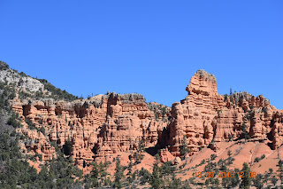
Bryce Canyon National Park, is a sprawling reserve in southern Utah, it was settled by Mormon pioneers in the 1850s and was named after Ebnerzer Bryce, who homesteaded this area in the area in 1874. The major feature of the park is Bryce Canyon, which despite its name, is not a canyon, but a collection of giant natural amphitheaters. Bryce is distinctive due to geological structures called hoodoos, formed by frost weathering and stream erosion of the river and lake bed sedimentary rocks. The red, orange, and white colors of the rocks provide spectacular views. We hiked The Rim Trail...this 4.5mile trail spans the rim of the amphitheater, and sends you down to the river bed and back up it offers you incredible scenery.
After our sailing adventure on Adagio we have become the driving adventures of the RV Esprit, a 1999 Holiday Rambler with her crew of four...our little Navigator "Navi", is brother Kenai...and of course the humans, Pierre and Bambi Lesne. This blog is written for the eradication of seemingly incurable sadness, so read me, for some smiles!
Pages
I never follow directions or instructions..I love the sun on my face and I am a fan of all things..
Saturday, February 20, 2021
Tuesday, January 5, 2021
Parowan Utah
When we left Yellowstone we decided to visit our friends in Parowan Utah, now If you’re looking for some Southern Utah history, Parowan is where it all began settled in 1851, Parowan is called the “Mother Town of the Southwest, because of the many pioneers who left from there to start other communities in southern Utah.
It is a quaint and beautiful place and we loved our stay with them.
They took us to Parowan Gap this is a sacred Native American site where there is a land formation called a “wind gap,” , at one time a river cut a notch 600 feet deep through the tilted rock layers, here you can walk the “gap” and see the all the petroglyphs on the huge boulders and rocks.
It is thought that Ancient Native Americans created petroglyphs by pecking and scratching the top layer of brown desert varnish, this reveals a lighter colored Navajo Sandstone underneath.
There were a huge variety of petroglyph images, there were geometric shapes, lizards, snakes, mountain sheep, bear claws, and human-like images.
One of the best-known petroglyphs presents itself as a large “V” and is referred to as the “Zipper Glyph.” According to the Bureau of Land Management, a Paiute tribal member in 1940 told a newspaper editor that the Zipper Glyph illustrated a map of travels with marks indicating the time spent along the route. In 1990, two archeologists studied the area extensively and suggested that the Zipper, with its regular marks along each side of the V, represented markers for a sun and a moon that would correspond to the four seasons. For example, the sun sets at the middle of the V at summer solstice. Further study revealed nearby ancient cairns and rock markers corresponding with equinoxes, cross quarters, and other annual solar events. Markings for the seasons would allow early inhabitants to plant and harvest crops during appropriate seasons and know when to prepare for the winter cold.
Experts have long debated the origin and meaning of the Zipper Glyph and other petroglyphs.
While studying many images, we were delighted how these ancient people had connected the movement of the sky with the seasons. Other images are believed to represent clan signs, maps, directions, ceremonies and songs. I bought a book on petroglyphs and used this as a references to the images and symbols.
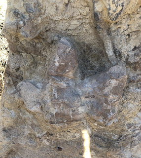
Scientists believe that Parowan Gap houses some 90 panels and 1,500 images, dating as far back as 5,000 years. The formation also includes intact dinosaur tracks nearby, and of course I love dinosaurs so we had to see this!!


